Geotag Photos Pro 2

คำอธิบายของGeotag Photos Pro 2
ระบุตำแหน่ง Pro ภาพถ่ายเป็นวิธีการแก้ใส่แท็กตำแหน่งมืออาชีพ - สิ่งที่คุณต้องระบุตำแหน่งภาพที่ถ่ายโดยกล้องภายนอกของคุณ (mirrorless DSLR หรือกะทัดรัด) มันสนับสนุน JPG และ RAW ภาพและข้อมูลสามารถนำมาใช้กับ Lightroom, รูรับแสง, Picasa และปพลิเคชันอื่น ๆ ภาพที่สนับสนุนรูป geotagged
ลอง 3 ทริปฟรีแล้วปลดล็อค app เต็มสำหรับค่าธรรมเนียมเพียงครั้งเดียว
Geotag Pro ภาพถ่ายได้รับการยกย่องโดยผู้เชี่ยวชาญในอุตสาหกรรม
- พิกัด App แห่งปีโดยนิตยสาร
- แนะนำซ้ำโดยนำผู้เชี่ยวชาญด้าน Adobe Lightroom
- แนะนำหนังสือที่ดีมากเช่น Lightroom 4 เผย Lightroom 4 คำถามที่พบบ่อยหายไป Lightroom 4 Roadmap สำหรับช่างภาพ
- ยกย่องจากนิตยสารชั้นนำของการถ่ายภาพและเว็บไซต์ทั่วทุกมุมโลก (TechRadar, Ephotozine, Fotomaf, Xatakafoto ลับ Lightroom, ดิจิตอล Fotografie, Pixelmania.nl, PhotoPlus ... )
ข้อเท็จจริงที่ดีที่สุดเกี่ยวกับการติดป้ายสถานที่ภาพถ่าย Pro
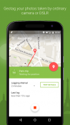
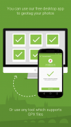
- โซลูชั่นที่สมบูรณ์แบบ - app มือถือบันทึกตำแหน่งของคุณในขณะที่คุณกำลังถ่ายภาพที่ดีและ app เดสก์ทอป geotags ภาพของคุณโดยใช้ข้อมูลที่บันทึกไว้
- Flawless Lightroom เข้ากันได้ - ไฟล์ GPX จากการทำงานการตรวจสอบไม่มีที่ติภายในโมดูลแผนที่ Lightroom สำหรับใส่แท็กตำแหน่ง
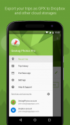
- Dropbox และการสนับสนุน Google Drive - การส่งออกโดยอัตโนมัติการเดินทางของคุณเป็นไฟล์ GPX ทั้งหมด
- แอพดูสมาร์ท - แอพเฉพาะสำหรับ Android และสวม Pebble ในการควบคุมแอพออกจากข้อมือของคุณ! อัพโหลดเดินทางอัตโนมัติ - การตรวจสอบโดยอัตโนมัติซิงค์ทุกการเดินทางของคุณ (คุณสามารถสลับไปยังภาพที่ส่งด้วยตนเองในการตั้งค่า)
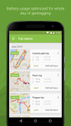
- การใช้งานแบตเตอรี่ที่ดีที่สุดสำหรับทั้งวันของการใส่แท็กตำแหน่ง
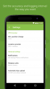
- เลือกช่วงเวลาที่เข้าสู่ระบบและความถูกต้องสำหรับสิ่งที่คุณต้องการ
- ทริปจัดประวัติศาสตร์
- สถิติของการเดินทางของคุณ
- ส่งออกไปยัง GPX
app เดสก์ทอปฟรีใส่แท็กตำแหน่ง
เพิ่มตำแหน่ง GPS ถึง JPG หรือภาพถ่าย RAW ของคุณได้อย่างรวดเร็วและง่ายดาย! ทำงานทั้งแบบออนไลน์และออฟไลน์และมีรุ่นสำหรับระบบปฏิบัติการใด ๆ - Mac OS X, Windows และ Linux แม้กระทั่ง
รูปแบบภาพที่รองรับ: JPG, NEF, CR2, CRW, DCR, CIFF, ERF, orf, K25, KDC, MEF, MRW, nrw, PEF raf, TIF, TIFF, ดิบ arw, RW2, SRF, SR2, SRW, X3F, DNG
เยี่ยมชมเว็บไซต์ของเราสำหรับข้อมูลเพิ่มเติม http://www.geotagphotos.net
Geotag Photos Pro 2--เวอร์ชั่น3.0.0
(13-12-2022)
Geotag Photos Pro 2 - ข้อมูล APK
เวอร์ชั่น APK: 3.0.0แพ็คเกจ: com.tappytaps.android.geotagphotospro2เวอร์ชั่นล่าสุดของGeotag Photos Pro 2
เวอร์ชั่นอื่น


แอปในประเภทเดียวกัน